Dedication to Col. Daniel Brodhead and his Men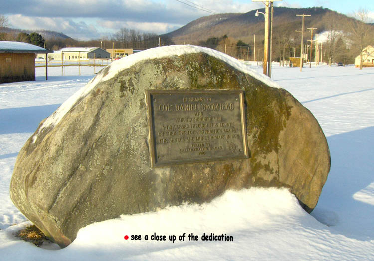
Photo credit: Felicia Diehl, 2007
A. P. Akeley, superintendent of schools in Potter county, is writing an interesting series of articles for the Coudersport Journal under the title: "Brodhead's Expedition of 1779 - Its Relation to Potter County." It is recalled that the Indians allied with the British, which constituted a serious threat to the Colonial because during the Revolutionary War expeditions were sent to destroy their source of food, particularly the corn crops along the Allegheny and Conewango, near Warren. Mr. Akeley has generously given the Democrat permission the reprint his interesting journal articles, the first of which follows: There is a local tradition which persists in saying that Col. Daniel Brodhead led a column of troops through the territory now known as Potter county during, or about, the time of the Revolutionary War. Usually this tradition has the march connected with Brodhead's expedition against the Seneca's in 1779 but not always is this true. Many old residents of the county tell that when they were children they heard the old folks talk about a road that was cut diagonally across the county by soldiers. Some of the old-timers insisted that they were able to follow the line of this road through the forests, when they were young, but at that early date, live and six inches in diameter, were growing in it. Roads now in use run over most of the line of the traditional road, but there are gaps where the exact route has been lost with the passing of years. Beebe in his history of Potter County, says: Here he turned east following the State line as nearly as possible, which made it necessary for him to cross the Allegheny River twice, the second crossing being near the present site of Bullis Mills, when he followed the Oswayo Valley to the present site of Ceres. Here he received news of General Sullivan's victory over the Indians, near the present site of Elmira, and the subsequent devastation of their homes in central New York state well known to students of U. S. History. He received orders not to join Gen. Sullivan, as his aid would not be needed. Then e pursued a southeasternly course across what is now Potter county. The road that he built along the line of his march for the transportation of his supplies we know as the Boon road. This road also served for a boundary of refuge for the non-fighting Indians of the Iroquois tribes, left desolate and in danger of starvation by General Sullivan's raid. At that time there was a price on the scalps of Indians in Pennsylvania. Within this refuge scalp hunting was forbidden. Gen Brodhead proceeded from Ceres up the right bank of the Oswayo. Near the present country line between McKean and Potter, he lost a horse, the skeleton of which being afterward found, gave the name of Horse Run to the small tributary that here enters the Oswayo at the present site of Coleville, coming up Whitney Creek, over Crandall Hill and down Steer Brook, crossed the Allegheny and following Prosser Hollow to Sweden Hill. The exact course he took from this point is not known, but it is certain that he followed nearly the present route of the turnpike through the Antes Fort, just across the river from Jersey Shore. Thence he made his was northwest through the present sites of Emporium, St. Mary's, Benzinger, Kane, and Kinzua back to the detachment he had left at the present site of Warren, arriving there September 14, 1779." Mr. John C. French, in an article published in the Potter County Journal
during the year 1922, has this to say: "The other two battalions moved east along the State line 40 miles to confluence of King's Run and Oswayo Creek then up the north bank Oswayo via Whitney Creek, Greenman Hill and Frink's Station on the Allegheny River east of Coudersport, Summit, West Branch, Abbott, Stewardson, into Lycoming county to Jersey Shore as H. H. Halt once described the route of the Boon road. The roads through the forest marking off the Brodhead district of approximately 40 miles square certainly were a boon to the early settlers of this great region. This 40 miles square was released by the Indians ignorant of arithmetic, in exchange for 40 square miles in New York State. It should be remembered that the Brodhead district was established as a safe asylum for the Indian refugees from New York State 25 years before the countries of McKean and Potter were erected as subdivisions of Lycoming County, it was Indian country until 1784." An examination of the records of the time, particularly the Pennsylvania Archives and the Colonial records does not support the statements made by these two men. On the contrary the facts given in the records are quite different than these two accounts. Daniel Brodhead was born in Marbletown, Ulster county, N. Y., in 1736. His great grandfather, also Daniel Brodhead was a royalist and a captain of grenadiers in the reign of Charles II. He came to America in 1664 with the expedition that captured the New Netherlands from the Dutch and later settled in Marbletown in 1665. His son, Richard, and Richard's son, also settled in Marbletown. In 1736 Daniel Brodhead Sr., moved to Pennsylvania and settled at a place named for himself, Dansburg or Dansville, not far from the present East Stroudsburg, Monroe county, When Daniel Junior was an infant, {to be continued next week} |