Go to the painted
panorama of 1858
See an
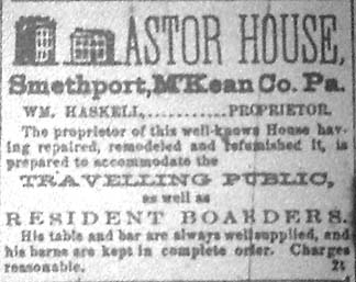
1858 Ad for the store located inside the Astor House Hotel
Pennsylvania’s
East-West Road:
The Northern Tier’s First Highway
Written by: Les Jordan Jr.
The construction of the East-West Road across Pennsylvania’s northern-most
counties was the single most important historical event that opened up the
region for settlement.
The Democrat of March 1, 1923 carried this article:The headline reads, “North
Tier Road Historic Highway.” The article then writes, “The movement
spreading so rapidly throughout the state, and especially through the North
Tier to have the Primary Highway connecting the county seats of the Northern
Tier improved as soon as possible, is given additional impetus by the discovery
that this highway follows the original survey authorized in 1806, and
adopted by the assembly in 1809, says the Galeton-Leader Dispatch.
The Federal government has designated this route as the “Great East-West
Highway,” and now we find that the original road, and the first road
laid out across the Northern Tier was known as the “East-West Road.”
This information comes from Robert R. Lewis of Coudersport, who has been
selected as a vice-president of the “East-West highway Association,”
(this association was mobilized to push the state into improving what was
to soon be U.S. Route 6, also known later as the Roosevelt Highway, and
the Grand Army of the republic Highway) and who is actively engaged working
for the early construction and improvement of this highway.”
The letter from Mr. Lewis follows:“The organization to advance an
East and West Highway through the Northern Tier ofPennsylvania recalls that
this is an old historic highway of Pennsylvania and one that wasknown many
years ago as the East and West road. In 1806 (Statutes at large of Pennsylvania,
Volume 18)page 471, or Smith’s law, page 391), an act was passed providing
for the appointment of Commissioners to explore and mark a road from
appoint where the Cochocton and Great Bend Turnpike passes through the Moosic
Mountains in a westerly direction to the west line of the state.
This road by the terms of the Act, was to pass through Wellsboro, by the
Great Meadows (Ansonia), and Pine Creek, to Coudersport thence to Smethport
and Warren. The Commissioners appointed to make a survey of the road reported
to the Governor.” That report was approved by and Act of Assembly
in 1808. Smethport’s Main Street became the route of that road, which
eventually became the important United States Route 6 following its designation
as the East-West Road.
Originally of dirt construction, the town paved this busy street with brick
in 1908, then with concrete in 1948. Smethport celebrated that event with
a huge “Street Opening Ceremony” on Saturday September 11, 1948.
The event was highlighted by Assemblyman Albert Johnson whose daughter,
Karen, cut the ribbon opening the street for traffic to once again flow
over The Roosevelt Highway as was then called Route 6. Smethport’s
own C.W. Lillibridge, retired Supervisor of McKean County Schools, provided
the key-note address. That address appeared in the Sept. 16, 1948 McKean
County Democrat According to Lillibridge, “In August of 1807
Francis King, agent and surveyor for the Keating Land Company whose headquarters
were then in Ceres, Pa., came to the forks of Potato Creek for the purpose
of plotting and surveying the town lots and streets of the newly designated
county seat of McKean. After building a rude camp, he and his helpers proceeded
with this task which took thirty-five days. Thus, the meets and bounds and
the general direction of Main Street and the road project which today is
being dedicated were established 141 years ago.”
Surveys were then made the following April of 1808 to plan the location
of a state road through the town. Lillibridge address pointed out that,
“In 1808 the Legislature of Pennsylvania authorized the East and West
road which extended from the Delaware River through the county seat towns
of the Northern Tier Counties to the city of Erie. From the days of its
early construction to the present this highway has been one of the chief
trunk lines of the county as well as northern Pennsylvania. With the exception
of the Port Allegany- Smethport and the Marshburg-Kinzua sections of this
highway, it follows closely the lines of the original survey. Entering McKean
County at Burtville, it ran parallel to the Allegheny River to the Canoe
place were the river was crossed.”
The July 6, 1934 McKean County
Democrat printed several articles in honor of Smethport’s Old
Home Week Celebration. The article’s headline reads, “History
of Smethport Had Vital Effect On Entire Section Of State.” The article
notes that, “In 1809 Benjamin B. Cooper petitioned congress to establish
a port at Smethport so that “ships” from Instanter might receive
and discharge cargoes. He bought 20 acres of land on Nunundah Creek and
made propositions to men to erect wharves.”
“As late as1840 the Allegheny River and Potato Creek were considered
navigable for steamships as far as Farmers Valley, six miles below Smethport.
The War Department still lists Potato Creek as a navigable stream, but the
dream of Smethport as a “port of entry” never materialized-although
it was a busy point in early lumbering days when log rafts were taken down
the river every spring.” (McKean County Democrat, July 26,
1934)
The McKean County Democrat of Feb. 12, 1942 notes that, “Cooper
and Joseph McIlvaine laid out the streets of Instanter in 1817,” using
the layout of Washington D.C. as their model. Instanter was a large development
on their lands in Sergeant Township. The settlement was near the present
community of Clermont. This settlement helped to fuel Smethport’s
growth and sent much traffic to the East-West Road.
Smethport’s first home, constructed in 1811 by Colonel Arnold Hunter,
was built beside the East-West Road as it entered the east end of Smethport.
The house was located at the intersection of present day Main and East Streets.
For years the intersection was known as McCoy Corners, named for one of
Smethport’s earliest pioneers, Dr, McCoy, who had his home and office
at that location.
An article in the May 26, 1932 McKean County Democrat notes that
in 1826 Orlo J. Hamlin found “that there were not more than a dozen
houses surrounding the brick courthouse.” If Smethport was ever to
achieve its dream of being a thriving community, it desperately needed a
system of roads to connect it to other important communities in Pennsylvania
and near-by New York State.
That began to materialize when, “Joel Sartwell, Hiram Pane and Jonathon
Marsh were commissioned to lay out the East-West Road in McKean County.”
The year was 1828. The road connected the county seats of Warren and McKean
County by way of Keating, Lafayette and Corydon Townships, a distance of
40 miles through the center of each county.
The 1828 McKean County map shows the location of the road marked in red
as it crossed the plateau from Port Allegany to Smethport. The map is from
the Pennsylvania State Archives.
Mrs. Anna Gates of Mount Alton read a paper about the highway at a meeting
of the Pamona Grange in 1928. The October 25, 1928 McKean County Miner
describes her report. Gates notes that, “some claim the original purpose
was to bind the inhabitants in loyalty, by means of communication, to the
street of Pennsylvania, as the Connecticut Company was extending for this
land at that time. Many of the pioneer settlers were from the New England
states. It was really a continuation of the Great East to West Road laid
out in 1816-1819 running from Kinzua on the Allegheny through the center
of the counties, Coudersport and on to Wellsborough.”
Old topographic maps show this original route in several locations. The
route traveled through Coudersport and entered Roulette. Lyman wrote about
the road as the “dug-out road” in his book about the History
of Roulette that he produced for that community’s centennial in the
mid 1960’s. The term was used in his grand father’s journal,
his grand father being one of the original settlers in that area of Potter
County.
A “dug-out” road was a big-deal in those days when roads were
not much more that old Indian paths through the woods. From Roulette, the
highway paralleled the Allegheny River along where the old Route 6 was located
prior to reconstruction in the late 1960’s, and entered Port Allegany
along
Main Street. There the road turned west onto Mill Street, crossed the Allegheny
River, and then climbed up the steep hillside onto the vast plateau between
Smethport and Port Allegany that the old-timers called the “Big Level.”
Lillibridge describes the road just after it crossed the Allegheny River
at Port Allegany. “The road then steeply ascended the mountain directly
west of that village to the highest elevation and thence directly westward
to the Potato Creek Valley and Smethport. Here the descent was made into
the valley by way of the ridge separating Fay and Riley (currently spelled
Reilly) Hollows, passing closely to the site of the Ralph Burdick cottage.”
Ralph Burdick’s cottage, owned later by the Angell family and now
owned by Bill Lake, is located in a clearing on the highest altitude of
Prospect Hill.
Residents of Smethport growing up in the 1960’s were able to see this
cottage, referred to as “Angell’s Camp, high on the hill aligned
almost due-east when looking east on West Main Street.
An article from the Aug. 13, 1938, McKean County Democrat reports
that, “R.E. Burdick is constructing a rustic pool below his cottage
on Prospect Hill, highest peak in this section of the country overlooking
Smethport. The pool is fed by a spring of crystal-clear water which was
used by pioneer farmers on the hill.” Water for man and beast was
crucial for highway travel, especially after such a steep climb from either
town. Many Smethport residents have visited the spot over the years to view
Smethport nestled in the valley below. Woods surrounding the camp have grown
high, and the view of town
is now blocked. According to Bill Lake, the East-West Road serves as the
northern boundary of his cottage property. The old road currently is used
as a snow mobile trail down the hill toward Smethport. The Burdick cottage
was originally located on the top of Bush Hill and was owned by the McCandless
family. It was moved to Prospect Hill in 1936.
The road from the parking area at the game lands toward Port Allegany can
still be
walked. It is narrow, barely passable in some spots, rutted with jeep trails
in other spots,
but is still discernable as an ancient road through the forest. The road
from the parking
area toward Smethport becomes difficult to detect at this point. It swerves
across the
Prospect Hill road toward the Fire Tower, passes just to the south of the
tower, then
begins the decline to the Potato Creek Valley as it travels north of the
Lake cottage and
down the gentle slopes to East Smethport.
I am uncertain where Fay Hollow is located, but suspect that it is where
Gifford Hollow
is today. In the 1950’s the Fay family had a farm at the head of the
hollow where they
sold brown eggs.
The map below shows the East-West Road marked in yellow. The original survey
for the
map dates to 1932.
Orlo J. Hamlin, one of Smethport’s earliest pioneers, writes about
his 1826 migration to
Smethport over the East-West Road in his journal, part of which was reproduced
in 2003
for Smethport’s Sesquicentennial book, Timeless Home.
“At the Canoe Place (now Port Allegany) we fell in with Moses Hana
who regularly
carried the mail from Smethport to Jersey Shore once in two weeks. We came
over the
hill, or rather mountain, I should call it, one of the most gloomy, lonesome
and
disagreeable roads I have ever traveled; all woods, the trees large and
numerous, and the
road being quite narrow shut out the site of the sun,-if it had shone in
December, which it
rarely does at our latitude and climate,-forming over us a complete canopy
of dark,
gloomy evergreens. The road was rocky in places, and stony nearly all, with
innumerable
roots of trees interlaced in the bed of the road for the horses to get over
as best they
could, at the risk of breaking a leg at every step, mud often knee deep,
and the more wet
or swampy places ornamented for crossing with an execrable corduroy or pole
bridge.
We slowly groped our way for nine long and seemingly endless miles to the
foot of the
hill east of Smethport; then for near half a mile we found another of those
most
intolerable of all bridges, made of logs and poles. Then crossing Potato
or Nunundah
Creek, arrived at the Red Tavern, kept by the widow Williard in Smethport.
Mrs. Williard
was not a widow, but as her husband had lately gone to the south, and left
her to take care
of herself and child, she became landlady and kept up the tavern as a means
of support.”
Orlo then describes his fist night in Smethport at the Red Tavern.
“It being long after dark when we arrived the barroom was pretty well
filled with men,
who just then had nothing else to do. After supper we rejoined the men in
the barroom
who were quite civil and neighborly, one of them who seemed a leading man
among
them, after inquiring whence we came and what we came for and learning of
our
proposed settling as a lawyer, asked me what spelling books were in use
now. I felt my
dignity as a lawyer put to the test, and was rather mortified that I should
be asked such an
undignified question, and replied under the infliction of a little mortified
pride, that it was
so long since I had been in the elementary school that I hardly knew what
spellers were
now in use, but I believed “Dillworths’s” were going out
and “Webster’s” coming into
use. Had he asked me some grave questions of law, I should have felt much
more
elevated, at least in my own estimation.
On retiring for the night I passed a small dining-room, which adjoined the
kitchen, from
that to my bedroom which was adjoining the barroom. It so happened that
a married man
and woman were then occupying a room immediately back of the dining-room,
and at
about ten o’clock at night the woman was in her accouchement, and
I was kept awake by
neighboring women passing through the dining- room to the sick woman’s
room every
few minutes, back and forth to the kitchen. In the barroom the men kept
up a continual
cross-fire of conversation with an occasional outburst of laughter. So to
me sleep was
impossible. About twelve I heard apparently the sound of one person, then
another falling
on the barroom floor, accompanied by the sound of laughter. This I inferred
resulted from
one man pushing another off his chair and landing him on the floor. This
to me is
intolerable nuisance was kept up until early morning, when the denizens
of the barroom
dispersed.
I rose in the morning feverish, nervous and excitable, fully determined
to return to
Towanda and take my chance there, rather than to settle in so outlandish
a place as
Smethport; but destiny had ordained it otherwise.”
Mrs. Gates tells about another interesting event at the “Red Tavern”
held on July 4, 1828
during a celebration in honor of the opening of the East-West Road. It involved
a joke
played on Mrs. Williard. The Oct. 25, 1928 Miner reported:
“Good music was necessary and as the best fiddler in county was a
guest of the sheriff.
Just then an understanding was had with the sheriff that the fiddler would
be present. The
ball was in the tavern of David Young. Mrs. Williard who ran the “Red
Tavern” was
indignant because her hotel had been slighted. She threatened the sheriff
if he furnished
the orchestra. The sheriff placed a dummy in the jail to replace the fiddler.
Mrs. Williard
peeked through the key hole at the jail but was fooled by the dummy. The
committee was
careful that she did not attend the dance. The ball was a success.”
According to Lillibridge, “Smethport, as the county seat, was naturally
the center from
which road building activities radiated. The village was connected with
Ceres by way of
Eldred and Farmers Valley where early settlements had been made. Likewise,
a road lead
southward to Gallup’s Corners in Norwich Township. Another was constructed
in a
southwesterly direction to Instanter (Clermont) the second oldest settlement
to be made in
the county.”
After noting several other roads radiating out of Smethport, Lillibridge
remarks, “We
must consider Smethport itself as the most important of these early pioneer
highway
junctions and for this reason: one of the greatest hardships that faced
the early settlers
was the lack of communication with friends and business associates left
behind in the
more thickly settled areas of the state. Thus we read that mails were sent
regularly from
Philadelphia to Ceres by way of Williamsport, but it was only when a chance
traveler
happened to be coming through that the mails were delivered from Williamsport
to the
far-away settlement of Ceres.”
Early settlers endured great hardships because of the poor conditions of
the dirt roads that
emanated from the community. Lillibridge reports that, “there were
the snows of winter,
the dust of summer and still worse the mud of spring and fall. Farmers and
townspeople
alike dreaded the time of the annual break-up when streets and country roads
were well
nigh impassible. The beautiful street now being officially opened and dedicated
must
have been at certain times of the year a veritable quagmire. The large logs
removed by
the contractor at considerable depth below the surface below the old brick
pavement are
evidences of the vain attempt of early settlers and roadbuilders to make
the streets of the
village more passable in the time of rains and mud. However, a sparse population,
lack of
local, county and state funds made these attempts fruitless for a century
or more. Those
who lived before the days of improved highways literally ate dust for a
part of the year
and then waded through mud halfway to their horses’ knees for another
part of the year.”
Lillibridge goes on to say, “Forty years ago Smethport remedied this
situation locally by
constructing a fine brick pavement along its Main Street. Then eight years
later in 1916,
the citizen of the county, quite largely under the leadership of civic-minded
residents of
Smethport, voted a bond issue of $750,000 for road building purposes, thereby
placing
the county as the first in the state to earmark upon a county-wide project
of this kind.
Since that time the state has contributed generously for roads and at the
same time taken
over the maintenance of practically all of the highways in the county. How
extensive and
beneficial those projects have been is evident in every borough and township
in the
county. Just how beneficial is evidenced by these simple statements. Forty
years ago
there were few schoolhouses in the entire county on improved roads. Children
walked to
school through snow and mud. Now there is not a single school building in
the county on
a dirt road. Efficient transportation are available for practically all
citizens of the county
no matter where they may dwell.
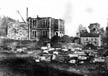
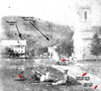
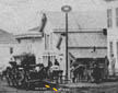
The photo below shows workman paving Main Street with brick in 1908.
McKean County Historical Society Archives
He adds, “The end is not yet. More and better highways are constantly
being built.”
Lillibridge then adds inspiration to his address. “The old brick pavement
has been torn up
and removed. In its place there is now a finer, stronger highway better
designed to meet
the increasingly difficult traffic conditions of modern times. Along the
old Main Street
there have taken place the usual and uneventful, but necessary, daily avocations
of typical
American community. If one had the time, the inclination and the data to
tabulate these
events and the men and women who took part in them since this street was
first paved
forty years ago, the list would be astounding as well as ennobling.”
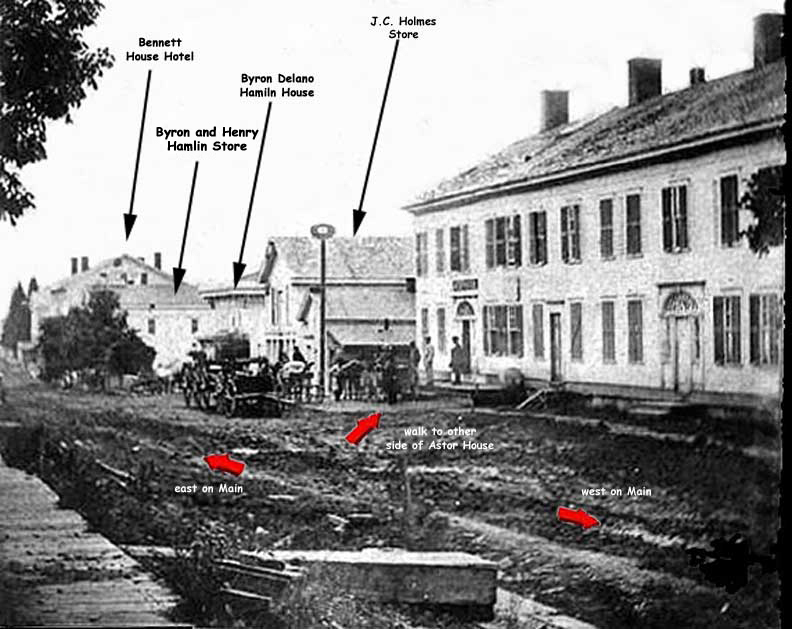
In Smethport, the East-West Road became “Main Street” and traveled
westward through
the town.
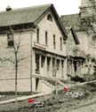
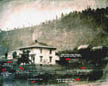
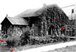
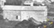
The photo below shows the East-West Road looking west from the 700 block
of West
Main Street circa 1865. The foreground building, known as the Astor House,
played a
key role in Smethport’s early development and served as an inn, general
store, tavern,
and community gathering area for townsfolk and travelers on the East-West
Road. Note
the terrible condition of the muddy road.
McKean County Historical Society Archives
The road climbed up Ormsby Hill west of town. The present location of Pennsylvania
Route 59 is located over the old East West Road up to the base of Ormsby
Hill. Here, the
old road deviated from the present highway in several spots as it snaked
its way up
Ormsby Hill. It is visible in several places to the right of the modern
highway. It is dug
into the slope of the hill and is barely wide enough for a wagon to pass
across with out
falling over the side of the road. Mid-way up Ormsby Hill, the old road
turns sharply up
the hill and parallels the headwaters of Blacksmith Brook, then makes a
sharp turn west
over the brook and enters Ormsby on what is today the Woodard Road. It then
crossed
the “Y” at Ormsby and travels along the present Route 59 once
again.
In the 1926 topographic map of the Bradford quadrangle showing the East-West
Road
crossing the Plateau toward Marshburg, it shows Route 59 as running from
Ormsby,
Cyclone, Gifford on today’s PA 646, then onto PA 770 through Minard
Run and into
Degolia on the present day PA 770, then south for a short distance on U.S.
219 to Custer
City and then onto PA 770 once again to Marshburg. Old Route 59 then joins
today’s
location of Route 59 at Marshburg, which is also the old location of the
East-West Road.
Note how an old wagon road to Bradford branched off the East-West Road at
Ormsby. It
is not known when this branch was constructed. This writer suspects it was
after the oil
boom and the Bradford, Bordell and Kinzua Railroad built its 3 foot narrow
gauge line
across the Big Level and into Smethport in 1880, since the wagon road paralleled
the
railroad pretty much from Davis to Ormsby.
On September 14, 1922, the McKean Democrat reported that the reconstruction
of the
road between Smethport and Ormsby was completed. “The highway has
been newly
graded and completely resurfaced and ditched. The huge rocks which lay in
the roadway
and made it apparently hopelessly, perpetually rough, have all been blasted
out and
broken up, the lose stone being used to fill up big depressions in the roadway.
The road is
now level as a floor.” At the time of the construction, the East-West
Road served as the
wagon road up Ormsby Hill.
Lillibridge stated that, “From Smethport the road passed through what
are now known as
Ormsby, Mt. Alton, Lafayette Corners, and Marshburg, and then directly westward
and
down into the Kinzua Valley by following the ridge separating Chapel Fork
from Sugar
Run Valley.”
Much of the route to Kinzua was widened and resurfaced in 1964 in response
to a
projected increase in traffic that would use the highway to visit the Kinzua
Dam, which
was under construction at the time. From Marshburg to Kinzua, Route 59 was
rebuilt on
an entire new location. This new highway merged with the East-West route
in some
spots, and wiggled across it or paralleled to it at other spots. The present
day Klondike
Road is built on the East-West grade, as is the current road to Kinzua Heights.
The old highway descended the hill on the ridge atop Sugar Run and entered
Kinzua from
the north, then traveled through the village and hugged the south bank of
the Allegheny
River as it gained elevation and made the sharp turn at Devil’s Elbow,
then proceeded
along the river to arrive in Warren. The modern Route 59 follows that same
course,
except for a change in the route at Devils Elbow.
The map below outlines the East-West Road across the western edge of McKean
County
and into Warren County at Kinzua.
The surface of the old road across the plateau between Marshburg and Kinzua
is in very
good shape. The area is part of the National Forest and I suspect that the
forest service
has maintained the old road in such a good condition.
Lillibridge ended his 1948 address with these words:
“In conclusion it can be said the roads of long ago were primitive,
but so were the times
in which the roads were built. The days of pick and shovel corduroy and
ox-team roads
are past. An increasing population with greater financial resources combined
with an
effective cooperation of local, county and state authorities have given
us a highway
system of which we can be proud. What of the future?
Highways are only a means to an end, and that end should be a finer and
better cultural
and industrial development of the people served by the roads. In the pioneer
days our
communications of necessity were self-contained. Each one, however small,
must solve
its own problems of civic, industrial and recreational nature. This called
for close
cooperation of citizen with citizen all along the line. The very highways
of which we are
so proud tend to make travel so easy and enjoyable that many communities
that many
communities lack that cohesion and cooperation of years ago. Are we not
thereby losing
something vital and necessary to healthful American life? Our roads are
built and taken
care of by the state. However, there are areas of activities in Church,
school, recreation
and industry where initiative and local cooperation must come from within
the small
community itself. The County and the state cannot do everything for us without
our
losing something essential that even the best of highways cannot compensate.”
Smethport’s early settlers desperately needed a highway to bring the
outside world to
their pioneer town for the same reasons noted by Lillibridge. Local townsfolk
like Joel
Sartwell, Hiram Pane and Jonathon Marsh, who laid out the original plan
of the East-
West Road through Smethport, played an important role in the areas development
in
1828. Local townsfolk continued to take an active role in the future of
their town when
numerous citizens mobilized in the early 1920’s to push for the improvement
and paving
of the Roosevelt Highway across the region and the entire state. Other townsfolk
continued the tradition as Smethport replaced its brick Main Street with
concrete in 1948
in a town-wide celebration. The tradition lives on today as numerous new
citizens work
to promote the same highway as did Hiram Paine and his friends after Smethport
was
chosen fas Pennsylvania’s First Route 6 Heritage Community.
This paper is copyrighted ©2007 by Les Jordan Jr.
McKean Citizen, November 13th, 1858.